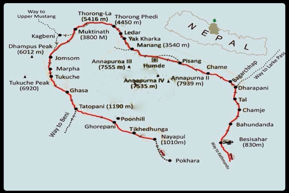
This page is designed to orient you to our travels in Nepal so that you can better understand where we are, what we’re doing, and where we’re going as we write the blog posts on these travels. Below you’ll find our calendar and route outlined, as well as a map showing the route and region in Nepal where we trekked.
Calendar
October 11-12 – Fly to Kathmandu
October 12-15 – Trek prep, namely running through the streets of Kathmandu for supplies and permits (Meghan’s college roommate, Jenny, joined us on Oct. 14 for a portion of the trek… Yay!)
October 16 – Local bus to the start of the Annapurna Circuit (AC) in Besisahar and begin trekking
October 16 – November 6 – Trek the AC from Besisahara to Nayapul (due to timing, Jenny trekked on without us starting Oct. 24 and returned to the U.S Oct. 30)
Novermber 6 – Local bus to Pokhara
November 6-9 – Relaxing in Pokhara
November 9 – Tourist bus to Kathmandu
November 10 – Fly out of Kathmandu
Route
The Annapurna Circuit (AC) is a famous trek in the Himalayas, although we had not heard about it before we started looking into trekking in Nepal. The route circles around the four Annapurna peaks and next to Dhaulagiri (Annapurna 1 and Dhaulagiri are the 10th and 8th tallest mountains in the world). The route started out as a trade route between mountain villages, and even though trekkers outnumber locals in the high-season, it’s still used for this purpose. There is currently a well maintained dirt road that runs most of the route, but we were able to stick to trails and avoid walking the road for the most part. There are many small villages along the route, and most have one or more guesthouses where one can eat and spend the night. Thus, a trek can be easily planned and begun in just a few days time as one is never more than a couple hours from a town.
Our route went as follows*
| Date | Started at | Ended at | Starting Elevation (ft) | Elevation Gained/Lost** (ft) |
|---|---|---|---|---|
| Oct 16 | Besisahar | Bhulbhule | 2,690 | 65 |
| Oct 17 | Bhulbhule | Ghermu Phant | 2,755 | 951 |
| Oct 18 | Ghermu Phant | Tal | 3,706 | 1,870 |
| Oct 19 | Tal | Danakyu | 5,576 | 1,640 |
| Oct 20 | Danakyu | Chame | 7,216 | 1,673 |
| Oct 21 | Chame | Upper Pisang | 8,889 | 1,968 |
| Oct 22 | Upper Pisang | Bhraka | 10,857 | 459 |
| Oct 23 | Bhraka | Bhraka*** | 11,316 | – |
| Oct 24 | Bhraka | Manang | 11,316 | 295 |
| Oct 25 | Manang | Gunsang | 11,611 | 1,189 |
| Oct 26 | Gunsang | Ledar | 12,800 | 976 |
| Oct 27 | Ledar | Thorong High Camp | 13,776 | 2,132 |
| Oct 28 | Thorong High Camp | Muktineth | 15,908 (Thorong-La pass at 17,764) | 1,856 / -5,300 |
| Oct 29 | Muktineth | Kagbeni | 12,464 | -3,280 |
| Oct 30 | Kagbeni | Marpha | 9,184 | -426 |
| Oct 31 | Marpha | Kalopani | 8,758 | -443 |
| Nov 1 | Kalopani | Ghasa | 8,315 | -1,722 |
| Nov 2 | Ghasa | Tatopani | 6,593 | -2,657 |
| Nov 3 | Tatopani | Sikha | 3,936 | 2,411 |
| Nov 4 | Sikha | Ghorepani | 6,347 | 3,067 |
| Nov 5 | Ghorepani | Hille | 9,414 | -4,576 |
| Nov 6 | Hille | Nayapul | 4,838 | -1,328 |
* We have no idea how far we trekked each day, though the entire route is around 140 miles. Maps give time between towns in hours, so we were clueless as to our distances.
** We hiked up and down a lot everyday. The elevation gain/loss is only calculated from the endpoints and does not reflect the actual daily gain/loss.
*** We took an acclimatizing day hike this day and returned to the same town.
Map of the AC

